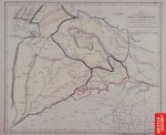
Map showing the extent of the Sikh territory at the death of Maharaja Ranjeet Singh and the partitions effected by the treaties.
production: 1846
courtesy British Library
This map was produced in 1846 but it shows the extent of Sikh empire till the death of Maharaja Ranjit singh thats around 1839.
Its preserved in the British library and this image can be found on their site.
Here's one more image but i don't know abt its authenticity. Also there is one point to be noted that during Maharaja Ranjit's rule Kashmir was part of Punjab. This image shows the map of punjab in 1846 when Dogras got kashmir by helping Brits.
Anyways daadi sigi tad hi rangi see. He was the person who did most of the sewa for Darbar sahib and he was also the person in whose RAAJ none use to be poor and everyone used to get lunch/dinner from the Raja himself.
He was the king of a large empire, even then on one of the wall of darbaar sahib. its written GURU DA NIMAANA JEHA SEWAK- RANJEET SINGH .. now that's being HUMBLE...

 for sharing veere nice info